Friday, July 15, 2016

Q is for Quantico


Q is for Quantico (click here for map). A beautiful two hour drive along Maryland’s Eastern Shore landed me in a small town that would easily appeal to visitors. Whether it is for the day or for the weekend, one could easily succumb to relaxation here by exploring the town’s history, “shooting a birdie” (in this instance, no harm to our feathered friends), camping, or just spending an afternoon doing what Marylanders do best (at least according to THIS site!)

In 1798, Quantico originated as a small mill and quickly evolved as a flourishing village in Wicomico County.  The town encompasses a total land area of 1.89 square miles and has 133 residents – some living in the 35 homes located along the along Quantico Creek.  As many of the Eastern Shore towns are associated with Native American heritage, Quantico is no exception.  Quantico means, “Place of Dancing” and was named for the creek by the Native Americans.   

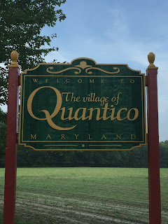
My GPS was the only thing letting me know I was closing in on the town.  There weren’t the typical green signs on the side of the road letting me know how many more miles I had left until I reached the town’s border.  Nope…. I just rounded a bend in a neighboring residential area and BAM!!!!!  The “Welcome to the Village of Quantico” sign appeared!  Alrighty then……camera fully charged?  Check!  My “To See” list ready?  Check!  Pen and note pad accessible?  Check!  Great - let’s get this party started!!

Unfortunately, many of the historical buildings the town once had are no longer standing.  One such building was the Quantico Hotel, which I pictured as distinguished because of the clientele.  The following is a excerpt about a few things the hotel was known for:      

The Quantico Hotel, owned by Thomas B. Gordy, was a stopping place for the state coach line which ran from Princess Anne to Cambridge by way of Whitehaven, Mardela, and Vienna.  Horses were exchanged and both drivers and passengers refreshed themselves.  The hotel was known for serving fine meals, especially their Snapper Turtle Pies.  After Gordy’s death, local Democratic leaders who met there to pick their candidates, award patronage, and have a good time drinking and feasting, continued the dinners.  This relationship came to an end in 1905 after Wicomico became a “Dry” county and the court ordered the bar to close. 
First United Methodist Church of Quantico
My disappointment quickly passed once I came across one of the buildings on my “To See” list - the First United Methodist Church of Quantico.  The church’s sign read, “Founded in 1778”, however, this was not the year the church was built.  1778 marks the year Methodism was brought to Quantico making it the first Methodist congregation south of Delaware.  This particular church started out as a chapel originally built about a mile from its present location.  In 1820, the chapel burned down and another one was built in its place.  In 1847, the church was moved to its present location.  After adding 14 feet to the structure, it was rededicated in 1848. 
Unfortunately, the structure is closed to the public since it is badly in need of repair.  However, I was able to walk about the property and take note of a couple of things – one being the bell tower, which houses a pretty interesting bell.  In 1848, this particular bell was cast in Baltimore and presented to the church upon its rededication.  According to towerbells.org:

[Baltimore] is home to the only historic American bellfoundry to have survived past the middle of the 20th century.  McShane Bell Foundry was one of the three major American makers of chimes, besides producing thousands of single bells and peals of 2 to 4 bells.   

If you access the list from the above McShane Bell Foundry link (the foundry is still in existence), 
Bell Tower
you will not find the bell listed that is located in Quantico, Maryland.  This is because the company did not start keeping accurate records until the late 1800s.  


Wooden slats cover all four sides of the bell tower, so you cannot actually see the bell.  By now, you’re probably asking what I found so interesting about this bell, aren’t you?  Well, I’ll tell you.…..I found it interesting because this bell has been tolled for every President of the United States who died in office since President Lincoln.  These Presidents were: 

                Abraham Lincoln (1861-1865)

                James A. Garfield (1881)

                William McKinley (1897-1901)

                Warren G. Harding (1921-1923)

                Franklin D. Roosevelt (1933-1945)

                John F. Kennedy (1961-1963)

So, is the bell still located in the tower?  “Yes”, according to a passerby.  He looked pretty young in age, so I doubt he would have heard the bell toll for President Kennedy! 
Time Capsule
Additionally, there is a granite marker outside the church where parishioners placed a Tricentennial Capsule (time capsule) in 1976 - it is to be opened in 2076. 
After spending a few more minutes at the church, I decided I would venture over to Camp Royal Oak.  Camp Royal Oak is part of the Veteran Support Centers of America.  This is a facility to assist our military veterans in their time of need.  Per their website, here is an excerpt from the description of Camp Royal Oak: 


VSCOA’s Camp Royal Oak is a first of its kind transitional residence program established to serve homeless and disabled veterans who have become homeless. The Camp serves honorably discharged veterans who are living honorable lives.  Located on a 50 acre campus Camp Royal Oak serves as home and employer to those who find their way to our front door.  It is located in Quantico on the beautiful Eastern Shore of Maryland, fifteen miles from Salisbury MD.  This is the Eastern Shore’s only program to serve homeless and disabled veterans who have become homeless.
Camp Royal Oak Entrance
A guest blogger (a military wife) was able to spend some time at the compound a couple of years ago, and wrote a beautiful article about her visit to the site.  If you have the time, please take a few minutes to read what she wrote.   I attempted to call before visiting Quantico to inquire about a possible visit, but nobody answered the phone.  I was hoping to drop in unannounced when I was visiting the town, but the entrance to the driveway had the dreaded “No Trespassing” signs posted on each side of the entrance.  I am certain the reason I could not reach the facility is because the veterans “stationed” here require extensive care and support, and do not need the general public invading their privacy.  As I have nothing but respect for what these servicemen did for our country, I wasn’t disappointed in the least I couldn’t access Camp Royal Oak.  I am grateful this establishment is here so the veterans are able to get the assistance they require.

The Sandy Hill Family Camp was another one of the Quantico sites I wanted to visit, and it happened to be located right down the road from
Camp Royal Oak.  I was hoping I would be allowed to tour the premises even though I was not one of their registered campers.  When I arrived to the campground, a sign at the entrance instructed me to visit the office to pay a nominal fee as a visitor.  I found the office/General Store, which was closed.  I think it was because I was at a campground on a weekend, and everyone was probably still relaxing or sleeping in.  However, there was a doorbell on the office door…..I rang it, and a few minutes later a women sleepily walked over from the house located across the street.  I explained why I was there and told her I wanted to pay the visitor’s fee.  
Recreation Center
She told me payment was not necessary if I was just going to be there for less than one hour.  She told me to feel free to walk around and take in the sights.  I thanked her and we parted ways. 


Wow!  This place was nice!  The campground is situated along the beautiful Nanticoke River and the views were spectacular.  Even with the day being a bit overcast, all was not lost – a grey sky, calm water, a fisherman quietly motoring by in the distance, 
Fisherman
and only the birds out and about were incredibly relaxing.  The campground was filled with campers, small boats and canoes, and the smell of campfires.  I walked around the yard surrounding the office admiring the view, and then saw a woman going into the adjacent building (which happened to be the “Recreation Center”.)  I followed her into the building and immediately started to comment on the how nice the campground was, and asked her if she knew anything about the history of the place.  And then I felt a little embarrassed – the rollers in her hair and the groggy look on her face told me it was a “tad” early for her to be engaging in all of this conversation!  She was extremely cordial, though (maybe she already had some coffee?) – she just smiled and told me she was going to ring the doorbell on the office door so the owner could come over and talk to me.  Nooooooo!!!!  Not the doorbell!!!!
Panic-stricken me:  “Really, Ma’am, you seriously don’t have to do that.  I can just call later and talk….”  She rang the bell.  Great.  And then the woman began to wander away.  Of course she did – even better.  I looked over at the house across the street (which I deduced was the owner’s house) and cringed as I watched a gentleman walking towards me.  I quietly chanted to myself, “Curb your enthusiasm, reduce the amount of questioning, and remember only the birds are awake!” (over and over, again.)  Thankfully, he didn’t look bothered at all when he reached me.  He asked if he could help me and I asked him if he could provide any information on the campground to me.  

He happily told me the campground was family owned and operated.  Back in the 1960s, there were only cabins on the grounds used for camping.  Those cabins have since
Sandy Hill Campground in 1960s
disappeared and the grounds are now used for campers/travel trailers only.  He told me that prior to the cabins in the 1960s, the campground was actually an amusement park and the office (where we were standing) was the building where a merry-go-round was housed.  Unfortunately, my research found no evidence an amusement park ever existed on the property, but it was an interesting story, none-the-less.  I then asked him about the campground’s amenities.  He told me there was a little sandy beach for sunbathing and swimming, boat ramps, a playground, and piers for fishing and crabbing.  He also showed me a map of the lots where you could put your camper/trailer.  I found it to be a very informative conversation.

Nanticoke River - Sandy Hill Camp
He explained that I was more than welcome to walk around the grounds, and if I had any questions to contact him either by going back in the office/General Store, or…….wait for it…….ringing the doorbell and he would be right over!  I laughed, thanked him for his time, and wandered around the immediate area for a few minutes. I found the entire campground to be well-equipped with activities and amenities – I would have everything I needed if I camped here.  Then I got back in my car and decided to take the long way out of the campground.  By now, people were milling about and beginning to visit with each other.  It looked like everyone was really having a good time!
Oldest Home in Quantico

Although it may have been early for the campers, I was starting to get hungry for lunch.  So, before I headed over to my lunch spot, I wanted to cross a couple of more items off of my “To See” list.  The first was the oldest house in Quantico.  According to Wikipedia, the house was built in 1790 with an addition added in 1810.   I found it interesting that the dates of the house can actually be traced by the nails used on the house.  Per John Carter, author of My Old House: How Nails Can Tell You the Age of Your House (a short article):
Before 1790 all the nails used were hand wrought from wrought iron. This was generally a two-man operation where one blacksmith made the nail’s shank then he passed it on to another specialist who formed the head in a special die. The head on these hand wrought nails usually displays for places where it was struck by a hammer forming the head.

The home does not face the street as it was built to face Quantico Creek, which was originally part of the property.  The house and three acres were sold in 1798 and purchased by Henry Crawford, a tanner, who gave the property the name Chelsea.  Census records show that the house, at the time, had a log cookhouse, stable, and meat house, as well as other commercial buildings such as a tannery, shed, bark house, and millhouse. 

I was unable to tell if the house had a tenant.  Research told me the house had been for sale, but there was not a “For Sale” sign in the yard.  The grass was overgrown, weeds were everywhere, and there was a wooden “Welcome” sign hanging from a branch of a small tree.  I did not see a “No Trespassing” sign posted, but did not want to take a chance on trespassing on the property if someone was living there.  So, I decided to get back on the road and work my way over to the other item on my “To See” list before having lunch.
Old Green Hill Church
I wanted to see the Old Green Hill Church (now, St. Bartholomew's Episcopal Church.)  The problem was there was not a number with the address listed – only the road that the church was on.  I found the road, which had a Dead End sign posted.  I drove the entire length of the road (roughly 5 miles, which ended at a private drive) and did not see the church nor the historical marker.  Did I miss something?  I decided that maybe I did, so I turned around and drove back (at a snail’s pace) to the beginning of the road.  Nope.  I still didn’t see anything.  Hmmmm.  I remembered that when I was conducting my research and ran across the marker, it had grid coordinates associated with it.  I pulled up the site on my phone, found the marker and grid coordinates, and entered them in my GPS.  That didn’t work – those coordinates brought me to a different city and state (I was probably entering them incorrectly).  And then I found it!!! 
Old Green Hill Church (Back)
The brilliant individual who posted pictures of the
marker ALSO posted written directions a few lines down from the grid coordinates!!!  I felt as if I had won the lottery!!! 
Once again, I started my journey and “this” time, I followed the directions provided on the website.  A few minutes later, I came across the sharp bend that was mentioned.  However, it was a house sitting in front of me and not a church.  Now what?  I saw an individual in the yard working and realized he was part of a lawn care service, and not the owner of the home.  I walked up to him and asked him if he knew of an old, historical church in the area.  He said, “Yes” and pointed to the area behind him, which bended around the tree line.  I remember reading I had to walk about 300 yards to actually get to the marker and church.  I asked him if it would be a problem going back there.  He said, “Not at all.” 

Now, the entire time I was talking to this gentleman, I was standing in front of a thick cable strung across what looked like a little drive going into the yard of the house where I was parked.  If I had to step over the cable, I would only have to raise my foot about 5 inches.   I told him that it didn’t look like I should be going back there because of the cable.  He told me not to worry.  People were always coming up to the cable with keys unlocking it to go see the church.  Keys?  Where the heck are the keys?!  I told him I didn’t want to drive to the church, I was fine with just walking.  He told me just to step over the cable and walk on back.  I asked, “Sir, do you live here?”  He said, “No” - he was just part of the lawn care service.  I was just about to say, “No, thank you.  I don’t want to trespass on private property” when I remembered that the church had a historical marker.  This church was something the public was allowed to see, right?  So, I stepped over the cable, hugged the tree line, and walked back to see the church. 

I saw the church and marker a few yards away, and then all of a sudden I became bothered by two things.  One, was the Deer Flies.  They were EVERYWHERE!  Try to take a picture when you are frantically swatting the air, and at the same time trying to get them out of your hair.  Why did I stay?  You guys read the story about how determined I was to find this place, right?  I risked possible arrest to see this church!!!  So, while I was running around in my flip flops swatting the air and trying to take pictures, the second thing I became bothered about entered my mind.  Snakes!  I was running around in VERY tall grass with the Wicomico River a few yards in front of me – a recipe for disaster!  As much as I wanted to stay and relish in the fact I was in a place not a lot of people have seen, I decided I should probably leave.  Luckily, I was able to take a few good pictures, never got bitten by a snake or a Deer Fly, and wasn’t greeted by the police as I was crossing back over the cable.  The lawn care technician was laughing a little bit as I ran away from the tree line towards my car.  He asked, “The flies?”  Yep……glad I made his day!  Haha!
By now, I was definitely ready for lunch.  I read The Red Roost was famous for their seafood.  I was pretty hungry for a crab cake, too.  After all, I “was” on Maryland’s Eastern Shore! 
One of the many walls with dollar bills affixed
When I entered the restaurant, I immediately noticed the countless, signed dollar bills that were affixed to the walls.  I had seen this before in another restaurant I visited.  Why were they there?  Here are a couple of theories: 

I have heard a couple of different stories. One is that it was started by fishermen who tacked a dollar bill to the ceiling of their local pub so that if they did not have any luck with the fishing that day, they would still have money for a drink at the end of the day. This type of insurance policy became a way of insuring good luck (sort of like the opposite of washing your car to make it rain). The other story I have heard is that soldiers and sailors going off to war would tack the dollar bill onto the ceiling in their favorite watering hole to insure that they would return home safely to reclaim their dollar and use it to buy their first drink (similar to how people will throw a coin into Trevi Fountain in Rome to insure that they will return to Rome someday).   

Stories/theories such as these have always interested me.  Will the real answer ever be known?  The world may never know! 

I was seated with a menu and a few minutes later, Tiffany came over to take my order.  I asked her how the crab cakes were.  For the life of me I couldn’t figure out why I asked her that question because the phrase at the top of the menu read, “Voted Best Crabhouse, Best Seafood, & Best Crab Cakes!”  Before Tiffany could laugh at me, I quickly ordered a crab cake to save myself the embarrassment of hearing her possibly say, “The statement at the top of menu says it all!”  However, I “did” ask her how it was prepared.  
Crab Cake
Tiffany smiled and told me it would be broiled and that there was no other option.  She told me there was probably .000000000005% filler

and because of that, the “all lump meat” crab cake would not stay together if it was put in a deep fryer.  Wow!  This was going to be good! 

By the way, I wanted to throw in that descriptor of the crab cake for effect – if you don’t know anything about crab cakes, you should know crab cakes made with lump crab meat are the best. 

As I anxiously waited for my lunch, I started to look around the room.  There were more dollar bills on the walls, and I noticed the lamp shades on the hanging lights were crab baskets. 
Metal Rail
Then I noticed a metal rail running along the length of the ceiling, dead-center down the middle of the room, which was at least 100 feet in length.  Odd - this building must have been something else before it was a restaurant.  I was going to get up and ask, but lunch arrived.  The meal I had only read about!!   It was beyond good – even beyond amazing! 
Tiffany stopped by to ask how everything was and it was at this point I asked her about the rail running along the ceiling.  She told me that the building was not always a restaurant – it was originally a chicken house in the 1940s.  It was only around for 15 or so years because during the last few years of its life, a series of floods drowned the chickens because of the way the roof was built.  In the early 1970s, it was converted to a recreation building on a campground that campers would use to cook food.  Additionally, the watermen from the Nanticoke would stop by to cook their catch.
Red Roost
It also attracted campers from The Roaring Point Campground in nearby Nanticoke – instead of driving over, the campers would motor over by way of boat.  However, the campground was difficult to get to during that time, so it closed.  In the mid-1970s, it was converted to The Red Roost restaurant and the rest is history.  Tiffany told me she has been working there for a little over 10 years and absolutely loves it! 

I needed to get on the road – there was one more thing to check off my list before heading home, though.  I was going to take a drive by The Green Hill Yacht and Country Club.
Club House

Now, I have to tell you I am not a golfer.  I just wanted to let you know the course was down there.  Here is a little information on the club per their website:

A long-time tradition on the Eastern Shore, Green Hill Country Club offers exclusive member benefits while enabling everyone to enjoy the challenging 18-hole championship course, special events and waterside bar and restaurant.  No matter what your lifestyle, Green Hill has something to offer. If you’re an avid golfer this par 72 course, set along the scenic Wicomico River with towering pines, provides a challenge time and time again. If you’re just a casual player, want to plan a fun golf outing, or think it’s time for a lesson, our pro will make you feel right at home. In addition to golf, we offer season pool passes and full social memberships for those interested in fun, year-round events.
I really needed to get back on the road and drive home.  Visiting Quantico was a wonderful experience and I am fairly certain there is an activity here that would appeal to just about anyone.  There was more “present” here than “past”, but that’s okay – the relaxation felt here was the perfect balance.  I absolutely loved this little town. 


Sunday, June 19, 2016

P is for Port Tobacco

P is for Port Tobacco (click here for map).  It took me only one hour to travel to the smallest incorporated town in Maryland.  Located in Charles County, this town is dotted with absolutely gorgeous old homes among rolling countryside along the Port Tobacco River, which happens to be an important tributary of the Potomac River.  Until I began researching Port Tobacco, I never would have believed this tiny town would have boasting rights to some pretty significant historical events.  Interestingly enough, the founding fathers of three holidays currently celebrated in the United States lived in this town.  I will explain more about these three individuals later. 

Now, when I say tiny town, I really mean tiny town.  Only 15 people call Port Tobacco home.  The town has a total land area of 0.16 square miles and is believed to be Maryland’s oldest continually inhabited settlement.  Originally, Port Tobacco was an Indian village.  A group of English settlers colonized it in 1634.  In 1727, it was established as the county seat of Charles County and was deemed the second largest port city in Maryland.  At its height during the 19th Century, Port Tobacco’s population reached nearly 300, but quickly declined after the silting of the river and the construction of the railroad in 1895 (several miles away), which resulted in the county seat being moved to nearby La Plata.  The few remaining historic structures, several reconstructed buildings, and several historic markers and plaques help to identify it as a unique and special place known today as Port Tobacco Village.  In 1989, the Town of Port Tobacco was designated as a historic district and was entered in the National Register of Historic Places of the United States. 

Before I continue, I want to mention there was not a “Welcome to Port Tobacco” sign.  The Port Tobacco marker I found was by the courthouse, which I would be touring.  The marker is significant because it references a reward for information leading to the capture of John Wilkes Booth, who assassinated Abraham Lincoln.  In summary of the assassination:

On 14 April 1865, Booth stopped by Ford's Theater in Washington to get his mail, and he discovered the President was to be at the theater that very night. Since Booth was an actor there, he had access to the building to plan his attack. Booth conspired with several other people that day; one of them was George Atzerodt from Port Tobacco who was supposed to assassinate the Vice President. Around 10:15pm, after making plans for a swift getaway, Booth entered Ford's theater and was allowed into the President's box, probably due to his fame as an actor.  He soon pulled out his Derringer and shot Lincoln one time in the back of the head. Booth then climbed over the railing of the President's box onto the stage, where his spur caught, causing him to fall and break his left leg. By 10:45 pm he was across the Navy Yard Bridge and on his way out of the city.

His first stop in Maryland was Mary Surratt's tavern (in Clinton, MD) for weapons and ammo, then he went to Doctor Mudd's house at Bryantown, Maryland, just a few miles from Port Tobacco, to have his broken leg set.  Later, he spent time just outside of Port Tobacco as federal agents searched the area.  Booth then crossed the Potomac into Virginia near the location where US 301 crosses the river today. Twelve days after Lincoln's assassination, Booth was killed in a shootout at Garrett's Farm in Virginia.

I will now continue with the history of Port Tobacco.  Tobacco was the local currency during the 1720s. For the European market, the leaves were packed in kegs and shipped to England.  In fact, tobacco was the #1 export of Port Tobacco and timber was #2.  Eventually, the town’s landscape began to deteriorate.  Tobacco ruins the soil (robs nutrients) and there was so much deforestation the land was eroding.  When it rained, topsoil washed off the hills and into the river, which clogged the shipping channel.  In the end, the larger masted schooners Port Tobacco once accommodated would be no more.  Only smaller craft were able to visit the port.  How ironic the planters who reaped prosperity by clearing the Port Tobacco Valley’s wooded hillsides for corn and tobacco were the cause of the port’s demise!

I called ahead to schedule a tour of three of the restored buildings in town.  Karen was my appointed guide.  Many of the things I wanted to see were not included in the tour, so I decided to arrive in Port Tobacco a few hours early to cross a few of the items off my “To See” list.  One of which was the Port Tobacco One Room Schoolhouse.  
Port Tobacco One Room Schoolhouse
The Port Tobacco School was used for seventy-seven years.  White students were enrolled from 1876 to 1924, and from 1924 to 1953 the school housed [African American] students.  The school usually housed grades one through seven.  In 1953, these students moved to a new Port Tobacco Elementary School farther west on Route 6.  The building was then used for 4-H Club meetings, and it served as a local library.  After Port Tobacco was entered in the National Register of Historic Places, the schoolhouse was named to be one of the town’s six historically significant buildings. 

I still had some time before I had to meet Karen, so I continued on my search for Mulberry Grove.  Mulberry Grove is a home that was the birthplace of John Hanson.  John Hanson was important for a couple of reasons and I will explain why in a moment.  The marker for Mulberry Grove was at the entrance of what looked like a long driveway.  It had a street sign, but my experiences in past towns told me street signs are not always assigned to street/public thoroughfare.  Streets/public thoroughfares do not have “NO TRESPASSING” signs even though a historical marker is planted.  As a “NO TRESPASSING” sign was not in existence, and the marker was posted at the entrance of this paved road, I figured it was fair game. 
I drove up a long, winding hill and finally saw the house.  However, there were some other buildings behind it on the property with cars in the yard, satellite dishes on the roofs, and other modern day amenities.  I decided not to go any closer to these other homes and just looked at John Hanson’s home.  I was undecided if this house was occupied (sometimes they are).  There were curtains in the windows, the yard was had been manicured, but I did not see any lights on in the house.  I nervously kept looking for that “NO TREPASSING” sign, as well!  I decided to stay long enough to get some pictures of the beautiful home and be on my way.  I never did determine if the home was occupied.

As mentioned earlier, John Hanson was important for a couple of reasons.  
John Hanson's Birthplace
He was the First President of the United States.  Wait!  What?  I know what you’re thinking……George Washington was the first President of the United States.  That, my friends, is a true statement.  George Washington was the first president
elected under the U.S. Constitution.  However, the predecessor to the Constitution was the
Articles of Confederation.  The Articles of Confederation also called for a president- one with greatly diminished powers.  Eight men were appointed to serve one year terms as president under the Articles of Confederation.  In November 1781, John Hanson became the first President of the United States assembled under the Articles of Confederation.

Remember I mentioned there are three individuals from Port Tobacco who I consider to be the founding fathers of three major holidays celebrated in the United States?  One of those individuals was John Hanson.  He was responsible for establishing the fourth Thursday in November as Thanksgiving Day.  

Looking at the time, I found I needed to leave in order for my tour with Karen.  I drove down the driveway (relieved to find a cop wasn’t waiting for me) and headed over to Stagg Hall to meet with Karen.  I got to Stagg Hall in time to see Karen opening the building.  She greeted me with a smile and told me I was the only one on the tour.  Pleasantries were exchanged and then she happily got down to business.  A few minutes into the conversation and I could immediately tell this was going to be a very educational tour – Karen clearly loved her job!

I mentioned earlier the tour consisted of three buildings.  Stagg Hall was going to be the first of the three.  Stagg Hall was a merchant headquarters built in 1740 for John Parnham who was established in the tobacco trade.  
Stagg Hall Great Room
Although it looks like a residence, it was used as an office and for entertaining.  As you enter the building, there is a large room to the left, which was the office space.  The room to the right as you enter the building was the room for entertaining, or The Great Room.  


This room was for entertaining male guests only.  There was absolutely nothing feminine about the décor – it was a statement room for men.  Which brings me to the spelling of the name on the building (Stagg Hall) and the picture of the invitation (Stag Hall).  There is a discussion on a blog pertaining to the difference in the spelling of the Hall’s name, which reads:  

I've often wondered why one of Port Tobacco's surviving 18th-century buildings, Stagg Hall, is so named.  What was Stag Hall (as spelled on the card)?  A fraternal organization like the Masons?  Or the Elks, an image of which appears on the card?  Did they meet at Stagg Hall, the house now occupied by Mrs. Dorothy Barbour?”   
 
(Mrs. Barbour is the former residential owner and there is more information on her in the reading below.  

Unfortunately, from what reading I have done on Stagg Hall, there doesn’t seem to be a concrete answer as to why the name of the Hall is spelled differently.   

Stagg Hall was bought and sold by several merchants until 1902 when it was finally sold to the Barbour family, who owned it until 2013.  Back in the 1920s, the Barbour family sold the Great Room to the Art Institute of Chicago.  The room was taken apart (floor, ceiling, décor) and shipped to Chicago where it was put together in the same fashion as it was in the house.  The Barbour family got the room back in 1972.  In 2013, Charles County purchased the home and began to historically preserve it.  In fact, Mrs. Barbour just turned 100 years old and will be coming back for a celebration. 

Karen showed me a very interesting thing about the house and I was thrilled I could get a picture of this, which probably occurred because it was so overcast (Karen said most people have tried and did not have any luck).  Look at the etchings in the glass in the windows.  
Window Etching
The etchings date back to the early 1900s.  This picture shows a name etched in the glass.  However, all of the other etchings were about weather observances – “Foggy”, “Cloudy”, “Blue Sky.”  I wondered if the idea was to take a grease pencil and circle the weather observance of the day to alert family members (wink)! 
 
From Stagg Hall, we walked over to the reconstructed courthouse – the second of the three buildings.  Unfortunately, the courthouse had to be reconstructed because the center part of the structure mysteriously burned to the ground in 1892.  
Reconstructed Port Tobacco Courthouse
At the time, Port Tobacco was the
county seat of Charles County.  When the town’s shipping industry was faltering because of silt in the Port Tobacco River and a new railroad which bypassed the town in favor of La Plata (three miles away), there was pressure to move the county seat to La Plata, but not everyone favored this.  To ensure the county seat actually moved to La Plata, arsonists were suspected of burning the courthouse.  A county seat generally won’t survive without a courthouse.  Per interview with the Washington Post, Mrs. Barbour said, "Three men took all the records out of the courthouse, put them on the grass, and burned the center of the courthouse.  They ignited it purposefully."   Who were the arsonists?  I happen to know," Mrs. Barbour said. "They were well-known, but we don't say because the families are still here in the county."  
Present Day Port Tobacco Courthouse
Three years later, the county seat was moved to La Plata as there was no money or willingness at the time to rebuild the Port Tobacco courthouse.  Businesses and residents followed.  Finally, Christ Church, which had stood next door to the courthouse for generations, was dismantled stone by stone and hauled away by ox cart to the new county seat.   
 
Only the middle portion of the courthouse burned – the wings did not.  Karen told me the South Wing became a Baptist Chapel and a small cemetery is located just outside.  In 1973, a courthouse replica was dedicated.    Architects were able to rebuild on the original footprint and use archived drawings/pictures to complete the exterior design.  
Port Tobacco Execution
The only struggle encountered was reconstructing the back of the building.  Unfortunately, the one drawing they found showing the rear of the courthouse was a depiction of an execution, which assisted in the finishing of the structure.  The current day courthouse LOOKS like the inside of a courthouse, but it is no longer used as such.  Karen said they hold weddings, dinners, and they even had a group of 5th graders perform a “mock trial” actually using the courthouse for its original purpose. 


Karen and I left the courthouse and walked over to the Burch House.  
Burch House
According to Karen and the summer 2015 edition of the Charles County Preservation Matters booklet, this house was owned by Washington Burch, an African American in Port Tobacco who progressed from being a slave, to becoming an emancipated citizen of Maryland, to finally becoming a prominent member in Port Tobacco.  Mr. Burch purchased the house in 1874, which was nine years after the Emancipation Proclamation was formed.  From there, he made his mark on history when he became a Delegate of the State for the District Republicans Convention. He also served as the African American representative on a committee to attend to voter registration lists.  Additionally, Mr. Burch, along with other African American men of the community, founded a school for African American children.  The school was once located outside of the Burch House, but no longer exists. 
 
Right outside of the Burch House is an active archaeological dig site led by the Charles County Archaeological Society. 
Findings from Dig
The county built a kitchen (solely for running water and counter space) in the Burch House so the crew could clean anything they found in the area, in addition to examining it and cataloging it.  Everything is then stored in boxes and placed on the top floor of the Burch House for reconstruction later (i.e., piecing together glassware).  The primary items found around the house and in the Port Tobacco community are
pipe stems 
Pipe Stems
from the long pipes used when smoking tobacco. 

The tour was over and I thanked Karen for a very educational experience.  I looked at the time and decided to head over to the Port Tobacco Marina and Restaurant for lunch.  On the way, I passed by the Ellerslie House, but was unable to stop because it is a residence and there was a “NO TRESPASSING” sign at the beginning of the drive.  This house has historical significance because it was the birthplace of Daniel of St. Thomas Jenifer.  Daniel of St. Thomas Jenifer is the second of the three individuals who are affiliated with holidays celebrated in the United States.  Daniel of St. Thomas Jenifer was one of the signers of the United States Constitution; thus making the holiday, Constitution Day (17 September). 

Lunch at the marina was fantastic!  
Maryland Rockfish
In true Maryland fashion, I ordered the Rockfish and it definitely did not disappoint.  The views from the restaurant were spectacular, which would be appealing to boaters and land lovers alike.  Three tiers of wooden decks with outside seating, slips for boats, great music, delicious food, and professional/personable wait staff easily translated into “your time with us will be nothing short of amazing!”, which it was.  I highly recommend this establishment!
 
After lunch, I decided to make my next stop Rose Hill Manor.  On my way, I stopped at a local vegetable stand.  Initially, I wanted to purchase tomatoes, but the gentleman behind the stand told me he just harvested their corn and “Ummm!  It…is...good”!  Then he hands me an ear with the husk pulled back and told me to bite the end off.  He would then add just five more ears to the bag, and charge me $3.00 for the half-dozen.  Quite the salesman!!!!   So, I took a small bite and do you know what?  Ummm!  It was good!  It was the sweetest corn I can ever remember having!  With a bag of produce in my hand
(I forgot all about getting tomatoes!), I thanked him and drove to Rose Hill Manor. 

Built in 1784, Rose Hill Manor is one of Charles County’s finest examples of formal Georgian architecture.  It is located on high ground with an expansive view of the Port Tobacco valley below.  I was interested in the Manor for a few reasons.
Rose Hill Manor
Source:  Historic American Buildings Survey
Thomas T. Waterman, Photographer
The first was it was once the home of
Dr. Gustavus Richard Brown.  Dr. Brown was a physician and friend of George Washington.  He was called to Washington’s deathbed at Mr. Vernon, Virginia, to act as one of his medical advisors.  The second interest was Olivia Floyd owned the home after Dr. Brown.  During the Civil War, Olivia Floyd lived at Rose Hill and became a spy and blockade runner for the Confederacy.  She made numerous runs behind the lines between Washington, DC and the Confederate capital of Richmond, Virginia.  Olivia was said to have outwitted a company of Union soldiers.  She conveyed papers, money and clothing from prisons and prisoners through the lines, and at one time, was holding $80,000 at Rose Hill to accomplish Confederate purposes.  She died at Rose Hill in 1905. 

The third and final reason I wanted to see the home was to look for a rock.  Allow me to explain.  This rock (“Peddler’s Rock”) is in the oldest ghost story in the United Sates, dating back to the 1700s.  The ghost story is – The Legend of Blue Dog or The Phantom Dog of Blue Dog Hill.  The legend is as follows:

According to the late Charles Stuart – a Rose Hill Road resident whose property contains the fabled rock that the Blue Dog and his master were killed on – the first written account of the Blue Dog Legend dates back to 1897. Rose Hill’s former owner Olivia Floyd, who was a former agent for the Confederacy during the Civil War, first told the Port Tobacco Times she had seen the ghost of the Blue Dog.

This once thriving seaport had many waterfront taverns.  One evening in February a stranger came to town and began drinking in one of those establishments.  This soldier, Charles Thomas Sims, boasted of his gold and deed to an estate.  After a long night of drinking Sims and his faithful dog, a large blue tick hound, left the tavern and headed out of town, taking Rose Hill Road.  Henry Hanos and his accomplices followed Sims up Rose Hill Road and attacked him to steal his money and deed.  During the robbery, Sims was killed and so was his dog, which valiantly tried to defend his master.  Both fell onto a large rock near the road.  Hanos then buried the gold and deed under a holly tree along Rose Hill Road.  The next day the townspeople found the peddler and the dog laying on the rock.  When Hanos returned to recover the treasure, he was scared away by the ghost of the Blue Dog and then fell ill, before suddenly dying. To this day, the Blue Dog reportedly continues to watch over his slain master's treasure.

Every February 8th, the Blue Dog returns to the spot where he and his master died. He howls and mourns for him beside the rock. This story has lived on for over 200 years….

There is a painter who painted the scene from this legend.  The original painting is hanging in the Blue Dog Saloon and Restaurant and you can order prints of this painting.  Most of the Blue Dog Legend accounts agree that the dog in the legend was an English Mastiff.  Mastiffs are among the largest breeds of dogs in the world and are known for their gentle spirit and protectiveness.  The painting depicts the grieving Mastiff, who was so black he was almost blue, on a cold February night lying next to his master’s treasure near the large quartz rock.
That is where the “Peddler’s Rock” comes into play.  The "Peddler's Rock" is a large rock with red stains and is said to still be present and located on the Rose Hill Manor property.  Earlier in the day, I mentioned to Karen I was hoping to see the rock.  Unfortunately, she told me Rose Hill Manor was private property and I probably would not be able to even see the house from the road because of all of the trees surrounding the dwelling.  She told me I would be able to see the two markers for Dr. Gustavus Richard Brown and Olivia Floyd at the beginning of the driveway, though.  She was right. 
When I got to the Manor’s driveway, I found the two markers AND the dreaded “NO TRESPASSING” sign on the gate of the property.  Was I disappointed?  Of course I was!  I wanted to see that rock!!! 

My disappointment was short lived as I remembered one of the main reasons I wanted to see this town – the Thomas Stone National Historic Park.  This park honors the life and work of Thomas Stone who was the third individual on my list who I considered to be a founding father of a celebrated United States holiday.  Who is Thomas Stone?  He was Maryland’s youngest signer of the Declaration of Independence.  Of course, the signing of the Declaration of Independence gave us Independence Day as a holiday (4 July). 

The park offers guided tours led by rangers from the National Park Service.  Ranger Abubakar was my tour guide and I would meet him at the house after viewing a 10 minute film at the Visitor’s Center, and a short walk leading me past the graveyard where the Stone family was buried.  The film was interesting – it provided insight into the life of Thomas Stone and of the house he built.  The house looked absolutely magnificent and I could not wait to get a tour.  Once the film was over, I only had to walk about five minutes through a field on the property to reach the graveyard where Thomas Stone and his family lay in rest.  There were several plaques for Thomas Stone on the wrought iron fence.  On 28 April 2013, a plaque at the foot of his grave was installed by The Society of the Descendants of the Signers of the Declaration of Independence.  From the graveyard, I walked another couple of minutes over to the house where I found Ranger Abubakar waiting.  Unfortunately, he told me I would only be able to see one of the two wings and the middle section of the house because the remaining wing was losing its battle with wasps! 

Habre de Venture
In 1771, Thomas Stone and his family settled into this home he called, “Habre de Venture”, which means, “Dwelling Place of Winds.”  It is a stately dwelling and another excellent example of Georgian architecture (one of the finest in Maryland).  This home is very unique in that it’s built in a semi-circle fashion – for no particular reason other than he liked the design.  A fire in 1977 destroyed the middle portion of the house.  Until that fire, the house was continuously occupied for more than 200 years.  The main block of the house was rebuilt and contains Thomas Stone’s original law desk and cabinets holding some of his possessions, which are located in the East Room.  
Thomas Stone Original Cabinets and Desk
A replica of the East Room is in the Baltimore Museum of Art.  At the time of his death in 1787, the estate comprised 1,300 acres, but currently consists of 322 acres with paths, open fields, a tobacco barn, two corn cribs, horse stables, a pond and the Stone family cemetery (I don’t know what happened to the other 1,000 acres).  A plaque was installed on the home’s memorial ledger on 4 July 1978 by the Maryland Society of the Daughters of the American Revolution.  Additionally, in 1881, the Stone family received 1 of 56 signed copies of the Declaration of Independence.  1881……remember, there wasn’t a copy machine.  Someone had to painstakingly replicate everything by hand. 

After I toured the home, Ranger Abubakar pointed me in the direction of the tobacco barn, 
Tobacco Hanging
corn cribs, and horse stables.  I spent another 20 minutes touring them and decided it was time to leave.  I wanted to visit two more places – Chapel Point State Park and St. Ignatious Church. 

Chapel Point State Park is located on the Port Tobacco River.  According to the county’s information page: 

Chapel Point is an undeveloped multi-use park that boasts a waterfront that offers excellent fishing.  A Maryland Bay Sport Tidal License is required.  Watch your tides before visiting this area.  At high tide there is almost no beach.  This area has a small sand launch area that is suitable for the launch of small john-boats, canoes and kayaks, and personal watercraft.  Hunting is permitted in the 600 acre state park.  The area provides suitable habitat for quail, squirrels, doves, rabbits, white-tailed deer, wild turkey and waterfowl.   Game hunting is permitted during the seasons established by the Wildlife Division.  Chapel Point has a small handicap hunting area.  There are three established hunter parking areas.  Sign-in boxes are located in each of those areas.  A maximum of 45 hunters is permitted at any given time.  Hunters may enter and remain on park property outside of the regular posted hours provided that they are engaged in legitimate, authorized hunting activity. 

Getting down to the waterfront proved to be a little challenging – mainly, because of the road conditions.  The main road to the waterfront was roughly four miles of packed dirt filled with pot holes – lots and lots of pot holes (my little car was not a fan.)  
Chapel Point State Park
However, the road is wide enough so you can easily dodge them as if you were driving on an obstacle course.  Just know you probably should not be sightseeing if you are the driver!  The “obstacle course” (as I called it) was short-lived though.  Once you reach the parking lot (wooded), you only have to take a short walk down a hill and then the beautiful Port Tobacco River appears before you.  The drive was definitely worth a front end alignment! 

My final stop in the town was St. Ignatious Church and St. Thomas Manor complex.  
St. Ignatious Church
St. Ignatious Church was founded in 1641
by Father Andrew White (an English Jesuit), and is one of the oldest Catholic parishes in continuous service in the United States.  Father White was among the first Jesuits to arrive in Maryland on the “Ark” and the “Dove” in 1634. He celebrated the first Mass in Maryland and set about establishing the church in this new land.  From its 120-foot bluff on Chapel Point, the church commands a majestic view of the Port Tobacco River where it joins the Potomac.  Attached to the church is St. Thomas Manor, which is the parish's Jesuit 
Port Tobacco River Meets the Potomac
residence – it was built in 1741 and is the oldest Jesuit residence in continuous use in the world.  

Located in the churchyard is the St. Ignatious cemetery.  A Civil War-era tunnel runs under the cemetery to the river.  It is possible this was used by runaway slaves in the Underground Railroad.  While conducting research on this town, I found out Olivia Floyd (Civil War spy) was buried in this cemetery.  I quickly located her grave and the small Confederate flag posted in front of her headstone. 

Sadly, it was time to head home.  As I started to drive out of town, I began to take note of how many old tobacco barns were still in existence.  
Olivia Floyd's Grave
They were everywhere!  Then I went over the entire day in my head, and was so amazed at how many things I actually saw of historical significance.  These were things I only read about in school – I never in a million years thought I would ever have the opportunity to stand in the home of someone who signed the Declaration of Independence!  I felt extremely fortunate for everything I was able to experience today.